We’ve got some quick and dirty pgRouting-based code up on github. I say quick and dirty because it directly references the table names in both of the functions. I hope to fix this in the future.
The objective with this code is to input a point, use a nearest neighbor search to find the nearest intersection, and from that calculate a drive time alpha shape.
First, the nearest neighbor search:
CREATE OR REPLACE FUNCTION pgr.nn_search (geom geometry) RETURNS
int8 AS $$

SELECT id FROM pgr.roads_500_vertices_pgr AS r
ORDER BY geom <#> r.the_geom
LIMIT 1;

$$ LANGUAGE SQL VOLATILE;
This function takes one argument– pass it a point geometry, and it will do a knn search for the nearest point. Since we are leveraging pgRouting, it simply returns the id of the nearest intersection point. We wrote this as a function in order to run it, e.g. on all the points in a table. As I stated earlier, it directly references a table name, which is a little hackerish, but we’ll patch that faux pax later.
Now that we have the ID of the point in question, we can do a driving distance calculation, wrap that up in an alpha shape, and return our polygon. Again, we write this as a function:
CREATE OR REPLACE FUNCTION pgr.alpha_shape (id integer, minutes integer) RETURNS
geometry AS $$

WITH alphashape AS(SELECT pgr_alphaShape('WITH
DD AS (
SELECT seq, id1 AS node, cost
FROM pgr_drivingDistance(''SELECT id, source, target, cost FROM pgr.roads_500'',' || id || ', ' || minutes || ', false, false)),
dd_points AS (
SELECT id_ AS id, x, y
FROM pgr.roads_500_vertices_pgr v, DD d
WHERE v.id = d.node)
SELECT * FROM dd_points')),

alphapoints AS (
SELECT ST_Makepoint((pgr_alphashape).x, (pgr_alphashape).y) FROM alphashape),

alphaline AS (
SELECT ST_MakeLine(ST_MakePoint) FROM alphapoints)

SELECT ST_MakePolygon(ST_AddPoint(ST_MakeLine, ST_StartPoint(ST_MakeLine))) AS the_geom FROM alphaline

$$ LANGUAGE SQL VOLATILE;
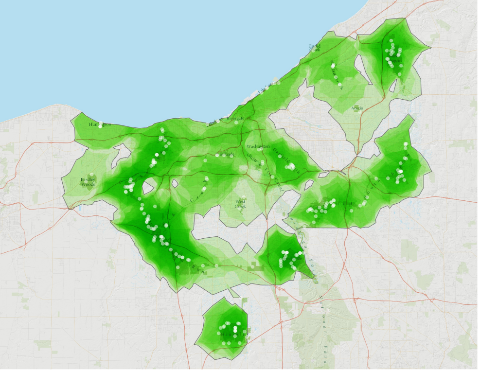
Finally, we’ll use these functions in conjunction with a set of park feature access points to map our our 5-minute drive time. Overlaps in 5-minute zones we’ve rendered as a brighter green in the image above.
CREATE TABLE pgr.alpha_test AS
WITH dest_ids AS (
SELECT pgr.nn_search(the_geom) AS id FROM pgr.dest_pts
)
SELECT pgr.alpha_shape(id::int, 5)::geometry, id FROM dest_ids;
Oh, and I should point out that for the driving distance calculation, we have pre-calculated the costs of the roads based on the speed limit, so cost is really travel time in minutes.

You might be interested to try out a recent improvement to the drivetime polygon function:
https://github.com/pgRouting/pgrouting/pull/237
The pull request is currently only available in the “develop” branch and needed some testing and feedback as well as updated documentation.
But I think it’s a very nice improvement to the current implementation.
Excellent. I’ll check it out.
Thanks for that example ! Very interesting ..
I’m not very familiar with postgis / pgrouting and have some doubts regarding the comprehension of that part :
> dd_points AS (
> SELECT id_ AS id, x, y
> FROM pgr.roads_500_vertices_pgr v, DD d
> WHERE v.id = d.node)
I guess the `pgr.roads_500_vertices_pgr` table refers to the table created when calling the topology function.
So where id_, x, y fields come from ?
Did you generated them before like that ?
> ALTER TABLE pgr.roads_500_vertices_pgr ADD COLUMN x float8;
> ALTER TABLE pgr.roads_500_vertices_pgr ADD COLUMN y float8;
> UPDATE pgr.roads_500_vertices_pgr SET x = ST_x(the_geom);
> UPDATE pgr.roads_500_vertices_pgr SET y = ST_y(the_geom);
Is `id_` different from generated native `id`. I’m a bit lost on that part. Thanks for your help.
A free web app for isochron calculations available everywhere in the world, enjoy (use SHARP mode) :
http://www.owlapps.net/application-geomarketing