I’m still working on this query, but I thought I’d post what I’ve done so far. My intent is to produce scale-dependent exaggeration of the distances between quasi-parallel lines. The reason for this is so that lines such as street lines which are nearly coincident at a particular viewing scale can be spread from each other, much in the same way great cartography lies a little to display a relatively correct map. The nice thing about digital cartography is that as we zoom in, we can make the lie a smaller and smaller, until it is just barely a fib :).
My thought was to start with the simplest case– move one line away from another (stationary) line. First step is to find the closest point on the stationary line, determine the distance and angle to that point, and then translate the point outward by some scale factor along that angle. Don’t take my code as gospel, though, I think there’s some deeper logical error, but see what you think:
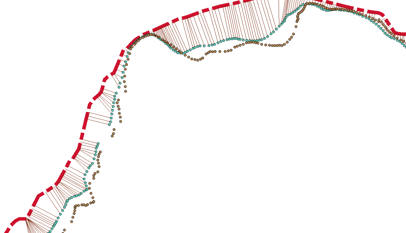
ST_ShortestLine gives us the shortest line from a given point to the road from which we are trying to offset. This is just to help visualize the problem:
CREATE TABLE shortLine AS

SELECT
	ST_ShortestLine(b.the_geom, ST_Union(a.the_geom)) AS the_geom
    FROM road2_points b, road1 a
    GROUP BY a.id, b.the_geom
    ;
Now, we try to translate the point outward at the same angle, by half again the distance to the closest point:
CREATE TABLE movedRoad AS
SELECT
	ST_Translate(b.the_geom,
		0.5 * ST_Distance(b.the_geom, ST_Union(a.the_geom)) * cos(ST_Azimuth(b.the_geom, ST_ClosestPoint(ST_Union(a.the_geom), b.the_geom))),
		0.5 * ST_Distance(b.the_geom, ST_Union(a.the_geom)) * sin(ST_Azimuth(b.the_geom, ST_ClosestPoint(ST_Union(a.the_geom), b.the_geom))) )
			AS the_geom
    FROM road2_points b, road1 a
        GROUP BY a.id, b.the_geom
    ;
Resulting in something looking like this (red dashed line is the road we are moving away from, the dotted blue are the points making up the line we are moving, and the dotted brown are the newly transformed points, with ST_ShortestLine also visualized in thin brown):


One thought on “PostGIS Cartographic Effects– Cartoonify Nearly Coincident Lines”