Ok @Mapbox, I’ve given you enough grace. I pulled the grumpy-old-man thing with Kenneth Field from ESRI a couple of weeks ago, and ended up apologizing. If i only give ESRI a few hours of grace, 3 months of grace for you is more than fair.
Now, to raise my foot up. We’ll see if it ends up in my mouth again.
Ok, so Mapbox and drones. Mapbox and drones. Those folks are excited about drones. They’ve got a toolchain their working on, and integration into their existing services, and lots of posts about drones. Downright giddiness I say:
https://duckduckgo.com/?q=site%3Amapbox.com+drones&t=canonical
And then this:
Really? 3 months ago, you launch “Don’t Fly Here”, create a repo for feedback and improvements to the data, but the biggest problem that you haven’t even tried to fix is the map really under represents the restrictions on where you should fly if you are trying to stay out of controlled air space, and the major update you do is adding temporary flight restrictions. Glitz and glory over getting the fundamentals right.
Here’s the current Mapbox no fly zones:
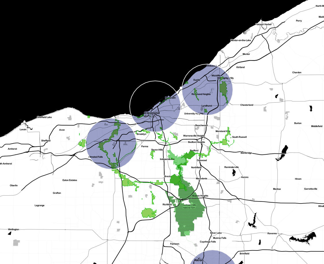
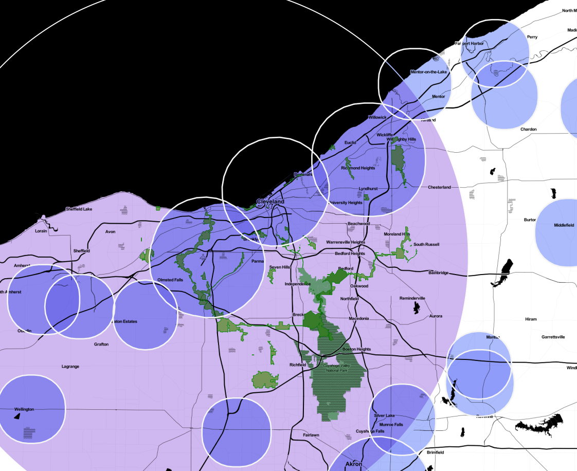
But, we are missing a lot of smaller airports that also have controlled airspace. Let’s be considerate to our hobbiest drone friends and put them in with 3-mile buffers and refine our 5-mile buffers on medium and large airports to include the edges of the airport, just to be on the safe side:

Well, that’s a bit less inviting. But hey, still plenty of places to fly, right? Uh, no. We forgot, according to the Aeronautical Information Manual, in certain busy airspace, there is a Mode C requirement for all craft flying in the airspace. This means you need to have a transponder to fly in this space between ground and 10,000ft above mean sea level. This is a transponder that weighs several times what your drone can lift — in otherwords a “non-starter”, effectively making these zones no-fly zones as well. What does Hopkins look like with it’s 30 nautical mile Mode C requirement?:
Now, to be fair, this is murky legal territory at best and I am not a lawyer. How much applies to hobbiests given the 1981 Advisory Circular I can’t say I know. But, if we are to propose a map to clarify where we can and cannot fly as hobbiests, then we should be including as much information (in a simple and easy to use way) as we can. On these grounds, “Don’t Fly Here” fails.
It’s cool though. It’s an open source data project in an open source community. Community contributions and knowledge will fix all mistakes in time, so my pull request to get to the second map will be reviewed and rejected on solid grounds or integrated, right?
https://github.com/mapbox/drone-feedback/pull/40
Three months later, I’m still waiting… . Fix your map please. Engage your repo users. Do this right. Please.

The apology was accepted and the storm in a teacup passed without drama though it’s heartening there are others who are equally as adept as I am at placing one’s foot in one’s mouth. Unsocial media makes it a default behaviour. Look forward to catching up with you at a future event.
Ditto, Ken. FOSS4GNA?
Here’s a loosely related story from Beijing:
“Three prosecuted for using drone to survey, photograph Beijing land”
http://online.thatsmags.com/post/three-prosecuted-for-using-drone-to-survey-photograph-beijing-land
Whoa: “A total of 1,226 military staff, 26 radar technicians and 123 military vehicles were deployed in response to the flight.”
Mode C requirement within 30nm in the C Veil is for “engine-driven electrical system” craft only and your usual drone doesn’t fall in this category. The 3 and 5 (n?)m circle generally cover any airspace that reaches the ground (compare with the shape files from https://nfdc.faa.gov/xwiki/bin/view/NFDC/56DaySub-2014-09-18).
As for the smaller airfields, they generally don’t have controlled airspace, most have class G uncontrolled airspace (hence the 3 (n?)mi as stated in the advisory).
Awesome. Thanks Anita.
I knew I wasn’t being nuanced in my post. I have a lot to learn yet too… .
You are correct about the class G uncontrolled airspace, hence the 3 miles, which is recommended if the person flying has not notified the local tower. Sorry for the abuse of terms.
I don’t know that there’s common agreement that the Mode C requirement doesn’t apply to typical drones. As I understand it, that requirement needs waived to operate under a Certificate of Authorization even for really light, electric motored craft. This indicates to me that it applies to all motorized craft. That said, I would guess that transponder requirements may not apply to hobbiests (but I’d probably be wrong). The 3 mile area around smaller airfields though is a recommendation for hobbiests.
But, all IANAL caveats aside, I don’t fly (yet), and have been slowly getting acquainted with the regs, recommendations, lore, and edicts.
In the mean time, I’m just trying to build great software, and prepare for when I can do some data collection for really cool natural resource and park applications.
This one still isn’t fixed: https://github.com/mapbox/drone-feedback/issues/22#event-147491606 – See Windsor, Ontario!
Oh dear. And it’s a closed issue.
I’ve bugged them about not having comments on their blog posts (no doubt because they use jekyll w/ bootstrap) to which they said ‘just use social media’ – but my tweets have gone unanswered multiple times, their forum is now on stackoverflow, and they don’t “do GIS”…