I consider myself an artist and scientist. I’ll confess I have let the art go fallow some in recent years, but these are two sides of one coin. If you like either, and especially if you like both, you should check out Tobias Research.
I met Michele at FOSS4G, where from the moment she saw my presentation on OpenDroneMap to using it to create a point cloud was a few short hours. I sat with Michele and her partner in crime, Alex, for a little while walking them through the (until then) undocumented steps of creating a mesh and texturing it inside MeshLab (to be fair to MeshLab, there’s plenty of docs on this, but there were none yet within the OpenDroneMap repo.
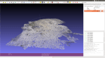
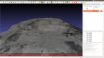
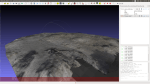
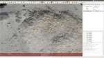
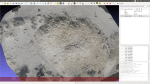
So, here’s some quick shots of her Kite Aerial Photography images for studying plant / dune dynamics processed through OpenDroneMap. Stunning kite aerial photography (KAP) work. The groundwork for great and beautiful science: